Maps for Schools
At Cosmographics we specially design maps that are aimed at a younger audience.
We have a broad selection of wall maps for all ages, some designed especially for the younger age groups and all our maps for schools and use in education are colour blind friendly. Colourful, easy to read and informative, our wallmaps are ideal for the classroom, home, school foyer or playground. We also give you the opportunity to turn our maps into a special gift or prize. You can personalise by giving us a title, name or picture to add. As well as our printed wall maps we have some useful map resources and activities available to purchase or download for free in our map resources section. Contact us you you would like a map produced that is centred on your school.
Click here to View our colour blind friendly Maps for Schools
Members of the Geographical Association get 15% discount, add the code at checkout
COLOUR-BLIND FRIENDLY MAPS
There is likely to be one child in every classroom that has a form of colourblindness. Find out more about colour blindness here. Our range of school maps have been specially designed to work for all forms of Colour Vision Deficiency (CVD).
Here are some examples of the maps we have:
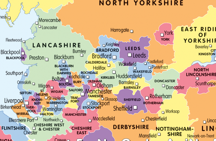
THE UK
Maps specifically designed to give as much information on the United Kingdom as simply as possible. Five colourful, informative maps , UK counties, 100 places to visit, physical, travel and a satellite image map of the UK.
WORLD, CONTINENTS, THE EU & THE COMMONWEALTH
Our political, physical and natural hazards world maps are especially designed for children/students, they are colourful and easy to read and use. We also have a satellite image world map showing the world in its true natural colours.
Included in our range of maps for the home or classroom is Cosmographics map of the European Union that clearly shows member countries with useful information on each one and also tracks the history of its membership.
We have a complete set of political and physical world and continental maps available to purchase and at different sizes.
MAP RESOURCES
A range of maps to download for free. Print and copy as many times as you like. Easy to read black and white maps designed to encourage learning.
In addition to our free world, continental and British Isles outline maps you can download, print and copy a range of themed maps for use in the classroom. Each free map download is a set of three maps designed to engage children in learning. Themes include major cities in the British Isles, major cities of the World, continents and oceans and lines of latitude and latitude.
We also have a range of map outlines that we can print at larger sizes for creative minds to colour, paint or stick on to. Purchase our colouring wallmaps (world, continental and the British Isles) printed at various sizes and encourage creative learning in the school or at home. You can personalise the maps too with your title of choice.
SCHOOL LOCATION MAPS
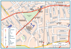
Maps designed and produced especially for your school. Place the location of your school at the centre of a map showing the detail relevant to your school and children. All maps designed are colour blind friendly. Maps are ideal for teaching children about their local area. Also a useful planning tool for the reception or office. Generally produced at A3 or A2 size, but that is not set. Can be supplied as a print ready file so you can print as many copies as you like or we can print, laminate or encapsulate as required.
Contact for more details and prices.
WHERE IS MY HOME OR SCHOOL
Enter your school or home postcode when purchasing and using Ordnance Survey mapping we will centre your map on it, see Location centred maps. We can customise the mapping, so if you need a different print size, a specific map area or would like your school name and logo added please contact us.
Free delivery in the UK when you spend £50 or more – use the code COSFREE